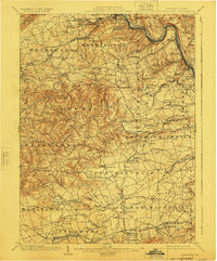
1902 Map of Slatington
USGS Topo · Published 1924About this map
Bake Oven Knob stands as a prominent landmark along Blue Mountain at the northern edge of this Pennsylvania landscape, overlooking a dense network of industrial and agricultural settlements. The early 20th-century economy of the Lehigh Valley is evident in the concentration of resource extraction and transit, from the Consolidated Quarries near Slatedale to the multiple rail lines serving the river corridor. The Lehigh River acts as a major artery, flanked by the Central R. R. of New Jersey and the Lehigh Valley R. R. through Slatington and Cementon.
Find a feature on this map
167 named features on this map. Tap any name to fly to it.
Don’t see what you’re looking for? This feature index may not catch every label — zoom into the map to look around manually.
Map Details
Editions of this 1902 Slatington Map
5 editions found
Other maps of this area

1888 · Quakertown
USGS Topo · 1:62,500

1889 · Hazleton
USGS Topo · 1:62,500

1890 · Quakertown
USGS Topo · 1:62,500

1891 · Hazleton
USGS Topo · 1:62,500

1893 · Hazleton
USGS Topo · 1:62,500

1894 · Reading
USGS Topo · 1:62,500

1894 · Allentown
USGS Topo · 1:62,500

1894 · Quakertown
USGS Topo · 1:62,500

1902 · Boyertown
USGS Topo · 1:62,500

1902 · Slatington
USGS Topo · 1:62,500