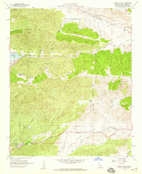
1958 Map of Sleepy Valley
USGS Topo · Published 1959About this map
The San Andreas Rift Zone creates a striking linear depression across this high-desert landscape, defining the northern edge of the Sierra Pelona range. In the late 1950s, the area remained largely pastoral, characterized by family-held properties like Ritter Ranch and the Annan Ranch. The Leona School serves as a central point for the Leona Valley community, which is concentrated along the Elizabeth Lake Road.
Find a feature on this map
51 named features on this map. Tap any name to fly to it.
Don’t see what you’re looking for? This feature index may not catch every label — zoom into the map to look around manually.
Map Details
Editions of this 1958 Sleepy Valley Map
3 editions found
Other maps of this area

1900 · Tujunga
USGS Topo · 1:62,500

1900 · Fernando
USGS Topo · 1:62,500

1901 · Southern California Sheet No. 1
USGS Topo · 1:250,000

1904 · Southern California Sheet No. 1
USGS Topo · 1:250,000

1915 · Elizabeth Lake
USGS Topo · 1:125,000

1917 · Elizabeth Lake
USGS Topo · 1:125,000

1929 · Lang
USGS Topo · 1:24,000

1930 · Ravenna
USGS Topo · 1:24,000

1931 · Del Sur
USGS Topo · 1:24,000

1932 · Red Rover
USGS Topo · 1:24,000