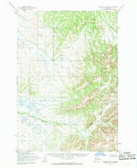
1954 Map of Sleetmute B-8
USGS Topo · Published 1968About this map
The Buckstock River meanders across the southwestern portion of this Alaskan landscape, defining the local hydrology alongside several notable tributaries. Mapped by the Army Map Service and published by the Geological Survey, this mid-century topographic study captures the interior's wilderness before modern infrastructure arrived. The terrain is characterized by the prominent elevation of Buckstock in the south, while Victoria Creek cuts through the northern sections. In the southeast, Kay Creek flows through the drainages of the Kuskokwim River region. This 1954 data, field-annotated just as aerial photogrammetric methods were being refined, shows an area primarily defined by its watercourses and elevation contours, with land lines representing unsurveyed locations predetermined by the Bureau of Land Management.
Find a feature on this map
4 named features on this map. Tap any name to fly to it.
Don’t see what you’re looking for? This feature index may not catch every label — zoom into the map to look around manually.
Map Details
Editions of this 1954 Sleetmute B-8 Map
This is the sole edition of this map. No revisions or reprints were ever made.
Other maps of this area

1947 · Russian Mission
USGS Topo · 1:250,000

1950 · Russian Mission
USGS Topo · 1:250,000

1950 · Sleetmute
USGS Topo · 1:250,000

1952 · Russian Mission C-1
USGS Topo · 1:63,360
1952 · Russian Mission B-1
USGS Topo · 1:63,360
1954 · Sleetmute C-8
USGS Topo · 1:63,360

1954 · Sleetmute
USGS Topo · 1:250,000

1954 · Sleetmute A-7
USGS Topo · 1:63,360
1954 · Sleetmute A-8
USGS Topo · 1:63,360

1954 · Sleetmute B-7
USGS Topo · 1:63,360