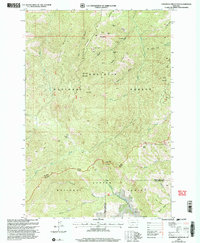
2000 Map of Sliderock Mountain
USGS Topo · Published 2005About this map
Mining history and high-elevation terrain define this landscape at the intersection of the Gallatin National Forest and Custer National Forest. The map documents a concentration of extraction sites along Iron Mountain and Gold Hill, including the Silver King Mine, Knapp Mine, and Surprise Mine. These names point to the late-19th and early-20th-century prospecting era when miners combed the gulches for precious metals.
Find a feature on this map
45 named features on this map. Tap any name to fly to it.
Don’t see what you’re looking for? This feature index may not catch every label — zoom into the map to look around manually.
Map Details
Editions of this 2000 Sliderock Mountain Map
This is the sole edition of this map. No revisions or reprints were ever made.
Other maps of this area

1891 · Livingston
USGS Topo · 1:250,000

1891 · Big Timber
USGS Topo · 1:125,000

1893 · Livingston
USGS Topo · 1:250,000

1893 · Big Timber
USGS Topo · 1:125,000

1898 · Granite Mountain District
USGS Topo · 1:125,000

1932 · Nye No 2
USGS Topo · 1:48,000

1939 · Mt Wood
USGS Topo · 1:62,500

1941 · Mt. Wood
USGS Topo · 1:62,500

1941 · Mt Douglas
USGS Topo · 1:62,500

1943 · Mt Douglas
USGS Topo · 1:62,500