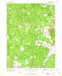
1955 Map of Slocum
USGS Topo · Published 1965About this map
Exeter and the surrounding rural townships of central Rhode Island are defined by a landscape of extensive wetlands and small, scattered settlements during the mid-1950s. The map illustrates the convergence of Exeter State Sch and the institutional history of the region, while the New York New Haven and Hartford Railroad provides the primary industrial artery, passing through the village of Slocum. Local community life is anchored by several social and religious landmarks, including the Slocum Grange, Liberty Ch, and the Baptist Church.
Find a feature on this map
72 named features on this map. Tap any name to fly to it.
Don’t see what you’re looking for? This feature index may not catch every label — zoom into the map to look around manually.
Map Details
Editions of this 1955 Slocum Map
5 editions found

Other maps of this area

1889 · Charlestown
USGS Topo · 1:62,500

1889 · Newport
USGS Topo · 1:62,500

1890 · Narragansett Bay
USGS Topo · 1:62,500

1890 · Kent
USGS Topo · 1:62,500

1892 · Narragansett Bay
USGS Topo · 1:62,500

1894 · Kent
USGS Topo · 1:62,500

1894 · Newport
USGS Topo · 1:62,500

1904 · Newport
USGS Topo · 1:62,500

1919 · Charlestown
USGS Topo · 1:62,500

1919 · Narragansett Bay
USGS Topo · 1:62,500