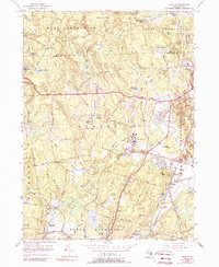
1955 Map of Slocum
USGS Topo · Published 1989About this map
Hopkins Hill and the surrounding woodlands of West Greenwich and Exeter define this mid-century rural landscape, where old family crossroads like Woods Corner and Cooks Corner still anchor the local geography. The map captures a transition period in Washington County’s interior, documenting small centers such as Slocum and Usquepaug alongside the institutional presence of the Joseph H Ladd Sch. Moving through the wooded terrain, the Penn Central line and historic thoroughfares like Ten Rod Road and Victory Highway connect these dispersed settlements.
Find a feature on this map
82 named features on this map. Tap any name to fly to it.
Don’t see what you’re looking for? This feature index may not catch every label — zoom into the map to look around manually.
Map Details
Editions of this 1955 Slocum Map
5 editions found

Other maps of this area

1889 · Charlestown
USGS Topo · 1:62,500

1889 · Newport
USGS Topo · 1:62,500

1890 · Narragansett Bay
USGS Topo · 1:62,500

1890 · Kent
USGS Topo · 1:62,500

1892 · Narragansett Bay
USGS Topo · 1:62,500

1894 · Kent
USGS Topo · 1:62,500

1894 · Newport
USGS Topo · 1:62,500

1904 · Newport
USGS Topo · 1:62,500

1919 · Charlestown
USGS Topo · 1:62,500

1919 · Narragansett Bay
USGS Topo · 1:62,500