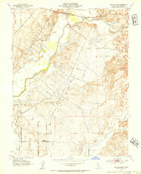
1953 Map of Sloughhouse
USGS Topo · Published 1954About this map
Sloughhouse and the fertile bottomlands of the Cosumnes River valley are shown here during the early 1950s, a period where traditional ranching began to meet modern infrastructure. The landscape is defined by the sweeping Levee systems and old land grants, notably the Omochumnes and San Juan boundaries. While much of the area remained agricultural, the scars of industrial extraction are visible through the extensive Dredge Tailings near the eastern hills. Local civic life is anchored by landmarks like the Alta Mesa Community Hall and the Alta Mesa Gun Club, alongside rural education hubs such as Cosumnes River School and the already Rhoads Sch (Aban'd). The drainage patterns of Deer Creek and Laguna Creek highlight the transition from the Sierra Nevada foothills toward the Central Valley floor, served by the Central California Traction Road and a network of named ranch roads.
Find a feature on this map
31 named features on this map. Tap any name to fly to it.
Don’t see what you’re looking for? This feature index may not catch every label — zoom into the map to look around manually.
Map Details
Editions of this 1953 Sloughhouse Map
2 editions found
Other maps of this area

1891 · Sacramento
USGS Topo · 1:125,000

1892 · Sacramento
USGS Topo · 1:125,000

1893 · Sacramento
USGS Topo · 1:125,000

1894 · Lodi
USGS Topo · 1:125,000

1902 · Fairoaks
USGS Topo · 1:62,500

1908 · Buffalo Creek
USGS Topo · 1:31,680

1909 · Elk Grove
USGS Topo · 1:31,680

1909 · Carbondale
USGS Topo · 1:31,680

1909 · Clay
USGS Topo · 1:31,680

1909 · Cosumnes
USGS Topo · 1:31,680