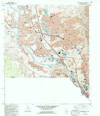
1994 Map of Smeltertown
USGS Topo · Published 1994About this map
Smeltertown and the Copper Smelter dominate the industrial landscape along the Rio Grande in this late-century look at the borderlands. The map traces a complex network of water management features, including the American Canal, Montoya Drain, and several water control structures like Mulberry Dam and Keystone Dam. These systems define the low-lying Mesilla Valley as it gives way to the rising slopes of Sierra de Cristo Rey and the Franklin Mountains State Park to the east.
Find a feature on this map
86 named features on this map. Tap any name to fly to it.
Don’t see what you’re looking for? This feature index may not catch every label — zoom into the map to look around manually.
Map Details
Editions of this 1994 Smeltertown Map
This is the sole edition of this map. No revisions or reprints were ever made.
Other maps of this area

1896 · El Paso
USGS Topo · 1:125,000

1908 · El Paso
USGS Topo · 1:125,000

1917 · Canutillo
USGS Topo · 1:62,500

1919 · Canutillo
USGS Topo · 1:62,500

1939 · Ysleta
USGS Topo · 1:62,500

1941 · El Paso
USGS Topo · 1:31,680

1941 · Ysleta
USGS Topo · 1:62,500

1942 · Fort Bliss
USGS Topo · 1:62,500

1943 · El Paso
USGS Topo · 1:31,680

1945 · Ysleta
USGS Topo · 1:62,500