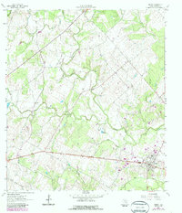
1962 Map of Smiley
USGS Topo · Published 1987About this map
Smiley serves as the primary hub in this portion of Gonzales County, situated at the junction of rail and road near the southern edge of the survey. The landscape is defined by the winding course of Sandies Creek, which gathers numerous tributaries including O'Neal Creek, Clear Fork Creek, and Little Elm Creek. This 1962 topography, updated in the early 1980s, reveals a rural economy shaped by agriculture and resource extraction, evidenced by a Poultry Farm to the north and various Oil Wells scattered across the terrain.
Find a feature on this map
23 named features on this map. Tap any name to fly to it.
Don’t see what you’re looking for? This feature index may not catch every label — zoom into the map to look around manually.
Map Details
Editions of this 1962 Smiley Map
2 editions found
Other maps of this area

1920 · Smiley
USGS Topo · 1:125,000

1942 · Dewville
USGS Topo · 1:62,500

1953 · Seguin
USGS Topo · 1:250,000

1956 · Dewville
USGS Topo · 1:62,500

1958 · Seguin
USGS Topo · 1:250,000

1959 · Cost
USGS Topo · 1:24,000

1961 · Sample
USGS Topo · 1:24,000

1961 · Nixon
USGS Topo · 1:24,000
1961 · Pilgrim
USGS Topo · 1:24,000

1961 · Gillett
USGS Topo · 1:24,000