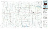
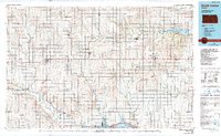
1985 Map of Smith Center
USGS Topo · Published 1985About this map
The Geographic Center of 48 States serves as a landmark for this North Central Kansas landscape, where the prairie grid is defined by a dense network of river forks and agricultural settlements. Towns like Smith Center and Mankato anchor the region, connected by the Missouri Pacific railroad line and federal highways. The landscape transitions from the river valleys of the North Fork Solomon River and White Rock Creek to significant water management features, including the expansive Waconda Lake and Lovewell Reservoir. This mid-1980s data highlights the established patterns of Smith and Jewell Counties, featuring numerous rural schools and churches often marked by quarries and small aviation sites like the Municipal Airport near Mankato. Local heritage is preserved in sites such as Fairview Cem and the surrounding wildlife areas that follow the natural drainage of Buffalo Creek and its branches.
Find a feature on this map
70 named features on this map. Tap any name to fly to it.
Don’t see what you’re looking for? This feature index may not catch every label — zoom into the map to look around manually.
Map Details
Editions of this 1985 Smith Center Map
2 editions found
Other maps of this area

1892 · Concordia
USGS Topo · 1:125,000

1892 · Minneapolis
USGS Topo · 1:125,000

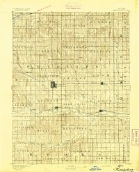
1893 · Smith Center
USGS Topo · 1:125,000
1893 · Phillipsburg
USGS Topo · 1:125,000

1894 · Mankato
USGS Topo · 1:125,000

1894 · Beloit
USGS Topo · 1:125,000

1896 · Holdrege
USGS Topo · 1:125,000

1896 · Osborne
USGS Topo · 1:125,000

1896 · Plainville
USGS Topo · 1:125,000

1897 · Red Cloud
USGS Topo · 1:125,000