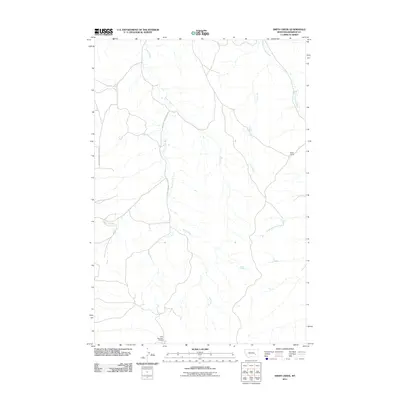
2011 Map of Smith Creek
USGS Topo · Published 2011About this map
Smith Creek meanders through this portion of Rosebud County, defining a landscape of drainage systems and isolated outposts in the Montana backcountry. The terrain is structured around the waterway and its various forks, with East Fork Smith Creek Rd and West Fork Smith Creek Rd providing the primary access through the territory. Near the eastern edge, Brock Camp represents the sparse human footprint in this ranching country, while Slaughterhouse Creek and the Long Prong contribute to the complex network of intermittent streams. At the southern border, the Friez Number 2 Dam indicates the importance of water management in this arid environment. This 2011 survey captures the area's enduring character as a sparsely populated region where geography and resource management dictate the pattern of settlement.
Find a feature on this map
7 named features on this map. Tap any name to fly to it.
Don’t see what you’re looking for? This feature index may not catch every label — zoom into the map to look around manually.
Map Details
Editions of this 2011 Smith Creek Map
This is the sole edition of this map. No revisions or reprints were ever made.
Other maps of this area

1954 · Forsyth
USGS Topo · 1:250,000

1957 · Forsyth
USGS Topo · 1:250,000

1958 · Forsyth
USGS Topo · 1:250,000

1968 · Orinoco
USGS Topo · 1:24,000

1968 · Nichols
USGS Topo · 1:24,000

1968 · Forsyth
USGS Topo · 1:24,000

1971 · Griffin Coulee NE
USGS Topo · 1:24,000

1971 · Smith Creek NE
USGS Topo · 1:24,000
1971 · Smith Creek
USGS Topo · 1:24,000
1971 · Mc Kerlich Creek
USGS Topo · 1:24,000