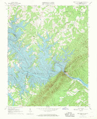
1967 Map of Smith Mountain Dam
USGS Topo · Published 1969About this map
Smith Mountain Dam serves as the focal point of this late 1960s landscape, where the Roanoke River and Blackwater River converge to form the intricate, branching arms of Smith Mountain Lake. The map captures a moment when the recently flooded valley transformed the topography of Bedford, Franklin, and Pittsylvania Counties, creating extensive shorelines that reach deep into former creek beds like Craddock Creek and Witcher Creek.
Find a feature on this map
39 named features on this map. Tap any name to fly to it.
Don’t see what you’re looking for? This feature index may not catch every label — zoom into the map to look around manually.
Map Details
Editions of this 1967 Smith Mountain Dam Map
Other maps of this area

1890 · Roanoke
USGS Topo · 1:125,000

1891 · Roanoke
USGS Topo · 1:125,000

1892 · Lynchburg
USGS Topo · 1:125,000

1921 · Chatham
USGS Topo · 1:48,000

1922 · Callands
USGS Topo · 1:48,000

1923 · Chatham
USGS Topo · 1:62,500

1924 · Callands
USGS Topo · 1:62,500

1944 · Callands
USGS Topo · 1:62,500

1947 · Roanoke
USGS Topo · 1:250,000

1951 · Moneta
USGS Topo · 1:62,500