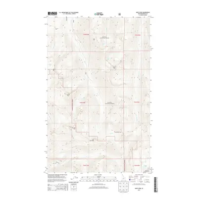
2013 Map of Smith Peak
USGS Topo · Published 2013About this map
Kanisku National Forest dominates this high-altitude landscape in the Selkirk Mountains of northern Idaho. The topography is defined by dramatic peaks and ridgelines, including The Lions Head and Lions Head Ridge in the south, and the namesake Smith Peak near the center. For researchers of backcountry history and wilderness management, the map traces a network of high-country basins containing remote water bodies like Smith Lake, Cutoff Lake, and Myrtle Lake. The drainage patterns are clearly delineated, showing how Smith Creek and the West Fork Smith Creek carve through the steep terrain. Human presence is sparse, marked primarily by the West Fork Cabin in the northwest and a few forest roads like 2446 and 281 that provide access to the Selkirk Crest Management Area. The inclusion of Long Canyon Pass and Long Canyon Creek illustrates the complex interior corridors of this protected forest area during the early 21st century.
Find a feature on this map
30 named features on this map. Tap any name to fly to it.
Don’t see what you’re looking for? This feature index may not catch every label — zoom into the map to look around manually.
Map Details
Editions of this 2013 Smith Peak Map
This is the sole edition of this map. No revisions or reprints were ever made.
Other maps of this area

1911 · Priest Lake
USGS Topo · 1:250,000

1913 · Priest Lake
USGS Topo · 1:250,000

1958 · Sandpoint
USGS Topo · 1:250,000

1963 · Sandpoint
USGS Topo · 1:250,000

1967 · Priest Lake NE
USGS Topo · 1:24,000

1967 · The Wigwams
USGS Topo · 1:24,000
1967 · Roman Nose
USGS Topo · 1:24,000

1968 · Smith Falls
USGS Topo · 1:24,000

1969 · Grass Mountain
USGS Topo · 1:24,000
1969 · Caribou Creek
USGS Topo · 1:24,000