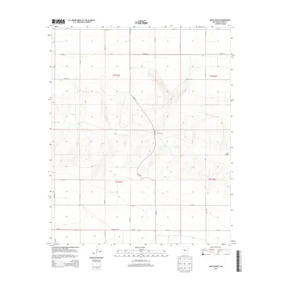
2013 Map of Smith Ranch
USGS Topo · Published 2013About this map
Smith Ranch sits at the heart of this High Plains landscape in Curry County, where the terrain is defined by the significant depression of Frio Draw. The map illustrates a strictly organized section-line road network typical of the Llano Estacado, with routes like Co Road Q and Co Road P cutting through the topographic contours as they descend into the drainage basin. This 2013 survey provides a clear look at the ranching infrastructure and land divisions within t6n r34e and surrounding townships. Along the southern edge, the transit corridor of State Route 288, also marked as Nm-288, connects this isolated ranching country to the broader region. The cartography emphasizes the relationship between the natural hydrology of the draw and the human-imposed grid of county roads.
Find a feature on this map
24 named features on this map. Tap any name to fly to it.
Don’t see what you’re looking for? This feature index may not catch every label — zoom into the map to look around manually.
Map Details
Editions of this 2013 Smith Ranch Map
This is the sole edition of this map. No revisions or reprints were ever made.
Other maps of this area

1954 · Clovis
USGS Topo · 1:250,000

1957 · Pleasant Hill
USGS Topo · 1:62,500

1957 · Hammond Ranch
USGS Topo · 1:62,500

1958 · Clovis
USGS Topo · 1:250,000

1971 · Broadview
USGS Topo · 1:24,000

1971 · Grady
USGS Topo · 1:24,000

1971 · Grady SW
USGS Topo · 1:24,000

1985 · Pleasant Hill NW
USGS Topo · 1:24,000

1985 · Smith Ranch
USGS Topo · 1:24,000
1985 · Garrett Ranch
USGS Topo · 1:24,000