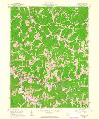
1961 Map of Smithburg
USGS Topo · Published 1963About this map
The Baltimore and Ohio Railroad corridor serves as the industrial and social spine of this Doddridge County landscape, threading through the narrow valley floor alongside the Middle Fork. This 1961 field-checked survey reveals a rural economy centered on the rail line, connecting small settlements like Smithburg, Morgansville, and Sherwood. The map is particularly rich for genealogists, documenting numerous small country churches and family-named cemeteries such as Knights Chapel, Chestnut Grove Ch, and Doak Cem tucked into the steep, wooded hillsides.
Find a feature on this map
68 named features on this map. Tap any name to fly to it.
Don’t see what you’re looking for? This feature index may not catch every label — zoom into the map to look around manually.
Map Details
Editions of this 1961 Smithburg Map
2 editions found
Other maps of this area

1904 · Vadis
USGS Topo · 1:62,500

1905 · Centerpoint
USGS Topo · 1:62,500

1905 · West Union
USGS Topo · 1:62,500

1906 · Holbrook
USGS Topo · 1:62,500

1924 · Centerpoint
USGS Topo · 1:62,500

1924 · West Union
USGS Topo · 1:62,500

1924 · Holbrook
USGS Topo · 1:62,500

1925 · Centerpoint
USGS Topo · 1:62,500

1925 · Vadis
USGS Topo · 1:62,500

1926 · Holbrook
USGS Topo · 1:62,500