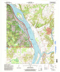
1996 Map of Smithland
USGS Topo · Published 1998About this map
The confluence of the Ohio River and the Cumberland River dominates this mid-1990s landscape, centered on the strategic river town of Smithland. The massive Smithland Lock and Dam controls the river traffic just above the junction, while the Lucy Jefferson Lewis Memorial Bridge carries motorists over the Cumberland. The terrain is marked by significant river bottomlands like McKinney Bottoms and a series of prominent elevations including Japanese Hill and Odarry Bluffs.
Find a feature on this map
52 named features on this map. Tap any name to fly to it.
Don’t see what you’re looking for? This feature index may not catch every label — zoom into the map to look around manually.
Map Details
Editions of this 1996 Smithland Map
This is the sole edition of this map. No revisions or reprints were ever made.
Other maps of this area

1916 · Golconda
USGS Topo · 1:62,500

1917 · Brownfield
USGS Topo · 1:62,500

1920 · Goloonda
USGS Topo · 1:48,000

1921 · Golconda
USGS Topo · 1:62,500

1926 · Paducah
USGS Topo · 1:62,500

1929 · Smithland
USGS Topo · 1:62,500

1929 · Paducah
USGS Topo · 1:62,500

1936 · Paducah
USGS Topo · 1:24,000

1936 · Smithland
USGS Topo · 1:48,000
1936 · Calvert City
USGS Topo · 1:24,000