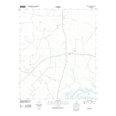
2010 Map of Smithland
USGS Topo · Published 2010About this map
The crossroads of Smithland define the center of this rural East Texas landscape, where local life follows the network of county roads and winding waterways. The map preserves the locations of several burial grounds essential for family history research, including the Rand Cemetery, Whatley Cemetery, and Moseley Cemetery. To the south, the terrain shifts into the complex wetlands and secondary channels of the river system. This area is characterized by features like Jenkins Slough, Old House Slough, and Carters Chute, which cut around the prominent Goat Island. The road network, comprised of routes like Shady Grove Rd and Mount Carmel Rd, connects these scattered settlements and cemeteries, illustrating the persistent rural character of Marion County in the early 21st century.
Find a feature on this map
41 named features on this map. Tap any name to fly to it.
Don’t see what you’re looking for? This feature index may not catch every label — zoom into the map to look around manually.
Map Details
Editions of this 2010 Smithland Map
This is the sole edition of this map. No revisions or reprints were ever made.
Other maps of this area

1944 · Kildare
USGS Topo · 1:62,500

1944 · Caddo Lake
USGS Topo · 1:62,500

1946 · Caddo Lake
USGS Topo · 1:62,500

1948 · Kildare
USGS Topo · 1:62,500

1956 · Tyler
USGS Topo · 1:250,000
1962 · McLeod
USGS Topo · 1:24,000

1962 · Lanier
USGS Topo · 1:24,000
1962 · Trees
USGS Topo · 1:24,000

1962 · Woodlawn
USGS Topo · 1:24,000
1962 · Smithland
USGS Topo · 1:24,000