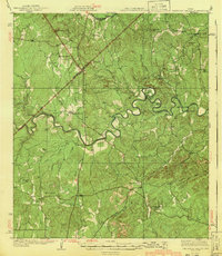
1940 Map of Smithson Valley
USGS Topo · Published 1940About this map
The Guadalupe River carves a winding path through this portion of the Texas Hill Country, creating dramatic oxbows at Demijohn Bend and Cordova Bend. This 1940 edition, based on surveys from the late 1920s, reveals a landscape of dispersed agricultural communities and isolated rural schools serving the Kendall and Comal county borderlands. Settlements like Fischer Store and Cranes Mill anchor the northern and eastern reaches, while Anhalt and Farmers Hall appear in the southwest, reflecting the region's early 20th-century social hubs.
Find a feature on this map
39 named features on this map. Tap any name to fly to it.
Don’t see what you’re looking for? This feature index may not catch every label — zoom into the map to look around manually.
Map Details
Editions of this 1940 Smithson Valley Map
2 editions found

Other maps of this area

1887 · Blanco
USGS Topo · 1:125,000

1894 · Fredericksburg
USGS Topo · 1:125,000

1894 · Blanco
USGS Topo · 1:125,000

1920 · Smithsons Valley
USGS Topo · 1:62,500

1925 · Hunter No 3
USGS Topo · 1:48,000

1925 · Smithson Valley No. 1
USGS Topo · 1:48,000

1927 · New Braunfels
USGS Topo · 1:62,500

1927 · Smithson Valley
USGS Topo · 1:62,500

1929 · Hunter
USGS Topo · 1:62,500

1929 · Smithson Valley
USGS Topo · 1:62,500