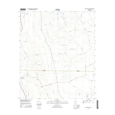
2014 Map of Smithville East
USGS Topo · Published 2014About this map
Muckalee Creek and its many tributaries, such as Philema Cr and Boggy Branch, define the hydrological character of this South Georgia landscape near the line between Sumter and Lee Counties. In the southwestern corner, the town of Smithville serves as a local hub, flanked by the Smithville Lookout Tower and the winding Muckaloochee Creek. The map documents a rural transition where agricultural roads like Old Hooks Rd and Hooks Mill Rd connect scattered settlements and family-named cemeteries, including Anthony Cem and Deldrich Cem. Significant water features like Well Millpond, Ballinger Lake, and Phillips Pond indicate a landscape heavily influenced by both natural drainage and local water management. The area around Nine Bridges and the small settlement of Maddox further illustrate the long-standing transportation patterns established long before the arrival of modern highways like Us 19.
Find a feature on this map
62 named features on this map. Tap any name to fly to it.
Don’t see what you’re looking for? This feature index may not catch every label — zoom into the map to look around manually.
Map Details
Editions of this 2014 Smithville East Map
This is the sole edition of this map. No revisions or reprints were ever made.
Other maps of this area

1953 · Dothan
USGS Topo · 1:250,000

1954 · Dothan
USGS Topo · 1:250,000

1955 · Dothan
USGS Topo · 1:250,000

1955 · Phenix City
USGS Topo · 1:250,000

1956 · Leslie
USGS Topo · 1:62,500

1957 · Phenix City
USGS Topo · 1:250,000

1958 · Phenix City
USGS Topo · 1:250,000
1972 · Methvins
USGS Topo · 1:24,000
1973 · Americus
USGS Topo · 1:24,000
1973 · Lake Collins
USGS Topo · 1:24,000