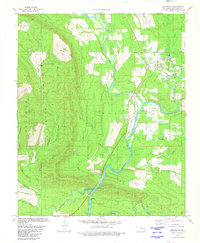
1981 Map of Smithville
USGS Topo · Published 1981About this map
Smithville and Octavia anchor this corner of McCurtain County, Oklahoma, in a landscape where the Boktuklo Mountains and Sulphur Mountain dictate the flow of water and human settlement. The drainage of Big Eagle Creek and Boktuklo Creek carve deep valleys through the terrain, meeting at the dramatic constriction known as The Narrows. This survey shows a transition in land use, noting the Indian Mission and the small settlement of Nani-chito. The map identifies specific infrastructure like the Footbridge near Smithville and a network of creeks including Buffalo Creek and Roosevelt Creek. A significant detail provided by the Oklahoma Water Resources Board notes areas subject to controlled inundation by Broken Bow Lake, indicating how the engineering of the regional watershed was beginning to reshape the lowland areas near the Fork Mountain ridge during the late 1970s.
Find a feature on this map
20 named features on this map. Tap any name to fly to it.
Don’t see what you’re looking for? This feature index may not catch every label — zoom into the map to look around manually.
Map Details
Editions of this 1981 Smithville Map
This is the sole edition of this map. No revisions or reprints were ever made.
Other maps of this area

1900 · Winding Stair
USGS Topo · 1:125,000

1902 · Lukfata
USGS Topo · 1:125,000

1909 · Winding Stair
USGS Topo · 1:125,000

1950 · Mcalester
USGS Topo · 1:250,000

1959 · Page
USGS Topo · 1:62,500

1960 · Bethel
USGS Topo · 1:62,500

1960 · Smithville
USGS Topo · 1:62,500

1962 · McAlester
USGS Topo · 1:250,000

1965 · McAlester
USGS Topo · 1:250,000
1966 · Ludlow
USGS Topo · 1:24,000