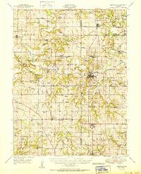
1950 Map of Smithville
USGS Topo · Published 1950About this map
Smithville serves as a primary hub where the Little Platte River meets the Platte River valley, anchoring a landscape defined by its river crossings and rural school system in the late 1940s. The area is marked by numerous family and community landmarks, including the Covered Bridge and historical crossings like Hixon Bridge and Rice Bridge. The settlement pattern follows a dense network of country schools such as Lone Star School, Stony Point School, and Prairie View School, which supported the dispersed farming communities across Preston and Platte townships.
Find a feature on this map
109 named features on this map. Tap any name to fly to it.
Don’t see what you’re looking for? This feature index may not catch every label — zoom into the map to look around manually.
Map Details
Editions of this 1950 Smithville Map
2 editions found
Other maps of this area

1890 · Kansas City
USGS Topo · 1:125,000

1894 · Kansas City
USGS Topo · 1:125,000

1894 · Independence
USGS Topo · 1:125,000

1910 · Leavenworth
USGS Topo · 1:62,500

1914 · Smithville
USGS Topo · 1:62,500

1925 · Gower
USGS Topo · 1:62,500

1925 · Plattsburg
USGS Topo · 1:62,500

1927 · Dearborn
USGS Topo · 1:62,500

1934 · Bonner Springs
USGS Topo · 1:48,000

1934 · Wolcott
USGS Topo · 1:24,000