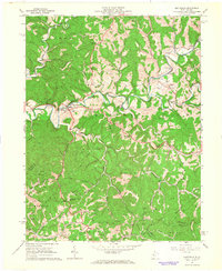
1964 Map of Smithville
USGS Topo · Published 1966About this map
Smithville sits at the junction of U S 33 and W Va 47, serving as a central hub for this portion of the West Virginia oil and gas fields. The landscape is defined by the winding course of the Hughes River and its South Fork, which carve through the high ridges of Murphy, Sheridan, and De Kalb districts. This 1960s survey illustrates a rural economy deeply integrated with natural resource extraction, as evidenced by the dense concentration of Oil Wells and Gas Wells peppered across the hillsides and creek bottoms.
Find a feature on this map
59 named features on this map. Tap any name to fly to it.
Don’t see what you’re looking for? This feature index may not catch every label — zoom into the map to look around manually.
Map Details
Editions of this 1964 Smithville Map
This is the sole edition of this map. No revisions or reprints were ever made.
Other maps of this area

1893 · Sutton
USGS Topo · 1:125,000

1906 · Holbrook
USGS Topo · 1:62,500

1906 · Glenville
USGS Topo · 1:62,500

1907 · Harrisville
USGS Topo · 1:62,500

1907 · Arnoldsburg
USGS Topo · 1:62,500

1924 · Harrisville
USGS Topo · 1:62,500

1924 · Holbrook
USGS Topo · 1:62,500

1925 · Glenville
USGS Topo · 1:62,500

1925 · Arnoldsburg
USGS Topo · 1:62,500

1926 · Harrisville
USGS Topo · 1:62,500