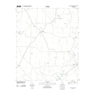
2011 Map of Smithville West
USGS Topo · Published 2011About this map
Smithville and the agricultural lands of western Lee County are defined by a complex drainage network where Kinchafoonee Creek and Muckaloochee Creek converge toward the southeast. The landscape is dotted with ancestral landmarks, from the Providence Cemetery in the northwest to the Williams Cemetery near the eastern boundary. Local industry and water management are evident through the presence of Davison Mill and several controlled water bodies like Wells Millpond and McCree Lake North.
Find a feature on this map
58 named features on this map. Tap any name to fly to it.
Don’t see what you’re looking for? This feature index may not catch every label — zoom into the map to look around manually.
Map Details
Editions of this 2011 Smithville West Map
This is the sole edition of this map. No revisions or reprints were ever made.
Other maps of this area

1953 · Dothan
USGS Topo · 1:250,000

1954 · Dothan
USGS Topo · 1:250,000

1955 · Dothan
USGS Topo · 1:250,000

1955 · Phenix City
USGS Topo · 1:250,000

1956 · Leslie
USGS Topo · 1:62,500

1957 · Phenix City
USGS Topo · 1:250,000

1958 · Phenix City
USGS Topo · 1:250,000

1973 · Dawson
USGS Topo · 1:24,000
1973 · Americus
USGS Topo · 1:24,000
1973 · Plains
USGS Topo · 1:24,000