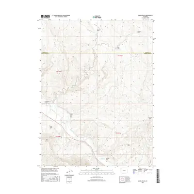
2016 Map of Smizer Gulch
USGS Topo · Published 2016About this map
The White River winds through this high-desert landscape of Rio Blanco County, defining a narrow corridor of managed water and rough relief. Agricultural efforts are evident along the river valley via the Blair Ditch, an irrigation feature that supports the land at the base of Blair Mesa and Blair Mtn. The surrounding terrain is heavily dissected by deep drainages, most notably the eponymous Smizer Gulch and neighboring Colorow Gulch. Further north, the land rises toward Rimrock Gulch and Sagebrush Draw, where the drainage of Crooked Wash cuts through the high plateaus. This area remains largely defined by its natural topography and early water management infrastructure, with Co RD 77 providing the primary transit route through the draws and gulches of the western Colorado interior.
Find a feature on this map
21 named features on this map. Tap any name to fly to it.
Don’t see what you’re looking for? This feature index may not catch every label — zoom into the map to look around manually.
Map Details
Editions of this 2016 Smizer Gulch Map
This is the sole edition of this map. No revisions or reprints were ever made.
Other maps of this area

1907 · White River
USGS Topo · 1:125,000

1910 · White River
USGS Topo · 1:125,000

1954 · Vernal
USGS Topo · 1:250,000

1958 · Vernal
USGS Topo · 1:250,000

1958 · Citadel Plateau
USGS Topo · 1:62,500

1960 · Vernal
USGS Topo · 1:250,000

1960 · Elk Springs
USGS Topo · 1:62,500
1966 · Smizer Gulch
USGS Topo · 1:24,000
1966 · White River City
USGS Topo · 1:24,000
1966 · Barcus Creek SE
USGS Topo · 1:24,000