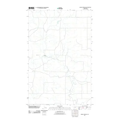
2011 Map of Smoke Creek NE
USGS Topo · Published 2011About this map
Smoke Creek winds through this section of Roosevelt County, defining a landscape of wide drainages and sparse ranching outposts in the Brockton District. The terrain is shaped by the subtle shifts of the High Plains, where the Burshia Coulee cuts toward the main creek bed. Human presence is centered on localized landmarks like West's Ranch, reflecting the enduring cattle-rearing traditions of northeastern Montana. A network of section-line roads and tracks, most notably Medicine Lake Rd in the north, provides the only primary access across these open reaches. This 2011 survey records the essential hydrography and infrastructure of the rural prairie before more modern developments, preserving the locations of specific ranch sites and coulees that have served as local reference points for generations.
Find a feature on this map
4 named features on this map. Tap any name to fly to it.
Don’t see what you’re looking for? This feature index may not catch every label — zoom into the map to look around manually.
Map Details
Editions of this 2011 Smoke Creek NE Map
This is the sole edition of this map. No revisions or reprints were ever made.
Other maps of this area

1909 · Smoke Creek
USGS Topo · 1:62,500

1912 · Smoke Creek
USGS Topo · 1:62,500

1914 · Homestead
USGS Topo · 1:62,500

1947 · Rocky Point
USGS Topo · 1:24,000

1948 · Rocky Point
USGS Topo · 1:24,000

1950 · Coyote Coulee
USGS Topo · 1:24,000

1954 · Wolf Point
USGS Topo · 1:250,000

1958 · Wolf Point
USGS Topo · 1:250,000

1982 · Culbertson
USGS Topo · 1:100,000
1983 · Homestead NW
USGS Topo · 1:24,000