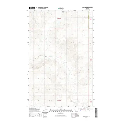
2014 Map of Smoke Creek NE
USGS Topo · Published 2014About this map
Burshia Coulee and Smoke Cr carve through the open landscape of northeastern Montana, providing a stark topographical contrast to the surrounding plateau. This 2014 survey reveals the persistent grid of the Public Land Survey System, specifically across Townships 30 through 32 North. The map captures the boundary line between Roosevelt and Sheridan counties, a critical reference point for local history and land ownership records. Transportation in this sparsely populated region is defined by gravel and dirt routes such as W Lake Rd, Homestead Rd, and Flat Center Rd, which follow the section lines of the high plains. The drainage patterns of the coulees suggest a landscape shaped by intermittent water flow, essential for the ranching and agricultural operations that define this portion of the Brockton District.
Find a feature on this map
12 named features on this map. Tap any name to fly to it.
Don’t see what you’re looking for? This feature index may not catch every label — zoom into the map to look around manually.
Map Details
Editions of this 2014 Smoke Creek NE Map
This is the sole edition of this map. No revisions or reprints were ever made.
Other maps of this area

1909 · Smoke Creek
USGS Topo · 1:62,500

1912 · Smoke Creek
USGS Topo · 1:62,500

1914 · Homestead
USGS Topo · 1:62,500

1947 · Rocky Point
USGS Topo · 1:24,000

1948 · Rocky Point
USGS Topo · 1:24,000

1950 · Coyote Coulee
USGS Topo · 1:24,000

1954 · Wolf Point
USGS Topo · 1:250,000

1958 · Wolf Point
USGS Topo · 1:250,000

1982 · Culbertson
USGS Topo · 1:100,000
1983 · Homestead NW
USGS Topo · 1:24,000