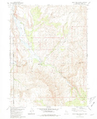
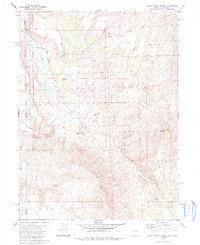
1980 Map of Smoke Creek Ranch
USGS Topo · Published 1981About this map
Smoke Creek Ranch sits at the heart of this high-desert basin where the California and Nevada border meets. The landscape is defined by the seasonal flow of Smoke Creek and its tributaries, including Burro Creek and the South Fork. This area preserves evidence of early transit and settlement in the Great Basin, notably at the Smoke Creek Station (Ruins) and the historically suggestive Robbers Roost (Site). Ranching infrastructure is visible through scattered corrals and water management features like Jenkins Troughs. A lone Grave near the creek serves as a poignant reminder of the isolation faced by early inhabitants. The presence of the Smoke Creek Airstrip and a Gravel Pit indicates the modern utility of this remote corridor, while the peaks of Burro Mountain dominate the eastern horizon.
Find a feature on this map
18 named features on this map. Tap any name to fly to it.
Don’t see what you’re looking for? This feature index may not catch every label — zoom into the map to look around manually.
Map Details
Editions of this 1980 Smoke Creek Ranch Map
2 editions found
Other maps of this area

1886 · Honey Lake
USGS Topo · 1:250,000

1886 · Granite Range
USGS Topo · 1:250,000

1891 · Honey Lake
USGS Topo · 1:250,000

1893 · Honey Lake
USGS Topo · 1:250,000

1894 · Granite Range
USGS Topo · 1:250,000
1954 · Wendel
USGS Topo · 1:62,500
1954 · Shinn Mountain
USGS Topo · 1:62,500

1955 · Westwood
USGS Topo · 1:250,000

1955 · Lovelock
USGS Topo · 1:250,000

1958 · Westwood
USGS Topo · 1:250,000