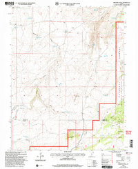
2002 Map of Smooth Knoll
USGS Topo · Published 2005About this map
High plateau ranching and water management define this terrain on the boundary of Wayne and Garfield Counties. This 2002 revision by the USDA Forest Service shows the eastern portion of the Dixie National Forest as it appeared at the turn of the millennium. The landscape is marked by an extensive network of small reservoirs and catchment basins used for high-altitude livestock grazing, including Mutts Reservoir, Blackburn Reservoir, and Bald Knoll Reservoir. These water sources are vital for the seasonal use of the surrounding wooded areas like Logging Grove and Peterson Grove. The map also traces the Loa Teasdale Ranger District line, illustrating the administrative complexity of these federal forest lands where drainage features like Balsam Hollow and Sage Hen Draw descend from prominent peaks such as Smooth Knoll and Timbered Knoll.
Find a feature on this map
32 named features on this map. Tap any name to fly to it.
Don’t see what you’re looking for? This feature index may not catch every label — zoom into the map to look around manually.
Map Details
Editions of this 2002 Smooth Knoll Map
This is the sole edition of this map. No revisions or reprints were ever made.
Other maps of this area

1885 · Fish Lake
USGS Topo · 1:250,000

1896 · Fish Lake
USGS Topo · 1:250,000

1952 · Loa 1 SE
USGS Topo · 1:24,000

1953 · Loa 4 NE
USGS Topo · 1:24,000

1956 · Salina
USGS Topo · 1:250,000

1960 · Salina
USGS Topo · 1:250,000

1962 · Salina
USGS Topo · 1:250,000
1969 · Smooth Knoll
USGS Topo · 1:24,000
1969 · Flossie Knoll
USGS Topo · 1:24,000
1969 · Jakes Knoll
USGS Topo · 1:24,000