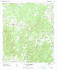
1963 Map of Smyrna
USGS Topo · Published 1978About this map
Smyrna and its surrounding countryside in Copiah County are defined by a network of rural churches and small-scale gravel operations. In the early 1960s, this landscape was anchored by congregational centers such as Mt Olive Ch, New Zion Ch, and Antioch Ch, which were often positioned alongside family cemeteries. The terrain is deeply carved by watercourses like Halls Creek and Valley Creek, creating a series of wooded ridges and valleys that dictate the winding paths of the local roads.
Find a feature on this map
29 named features on this map. Tap any name to fly to it.
Don’t see what you’re looking for? This feature index may not catch every label — zoom into the map to look around manually.
Map Details
Editions of this 1963 Smyrna Map
2 editions found
Other maps of this area

1953 · Natchez
USGS Topo · 1:250,000

1956 · Natchez
USGS Topo · 1:250,000

1959 · Natchez
USGS Topo · 1:250,000

1963 · Dentville NW
USGS Topo · 1:24,000

1963 · Dentville
USGS Topo · 1:24,000

1963 · Smyrna
USGS Topo · 1:24,000
1963 · Gallman
USGS Topo · 1:24,000

1963 · Hazlehurst
USGS Topo · 1:24,000

1963 · Barlow
USGS Topo · 1:24,000

1972 · Midway
USGS Topo · 1:24,000