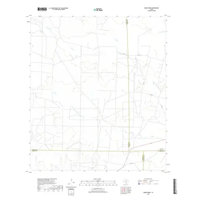
2019 Map of Snake Creek
USGS Topo · Published 2019About this map
Snake Cr and Cibolo Cr define the drainage patterns of this South Texas landscape where four counties meet. This 2019 survey captures the convergence of Frio, Zavala, Dimmit, and La Salle counties, a junction of rural boundaries marked by cattle-country roads like Hugo Rd and Chido Rd. The terrain is characterized by intermittent watercourses including Medio Cr, Big Hollow Cr, and Espio Cr, illustrating the hydrological network typical of the brush country north of the Rio Grande. With very few structures indicated, the map highlights the enduring agricultural and ranching character of the region, where the primary infrastructure consists of local connectors like Sandy Co Rd and Hurt Rd that navigate the low-relief plains and creek beds.
Find a feature on this map
16 named features on this map. Tap any name to fly to it.
Don’t see what you’re looking for? This feature index may not catch every label — zoom into the map to look around manually.
Map Details
Editions of this 2019 Snake Creek Map
This is the sole edition of this map. No revisions or reprints were ever made.
Other maps of this area

1939 · Big Wells
USGS Topo · 1:62,500

1942 · Divot
USGS Topo · 1:62,500

1953 · Crystal City
USGS Topo · 1:250,000

1955 · Crystal City
USGS Topo · 1:250,000

1956 · Woodward
USGS Topo · 1:62,500

1956 · Divot
USGS Topo · 1:62,500

1957 · Batesville
USGS Topo · 1:62,500

1961 · Crystal City
USGS Topo · 1:250,000

1968 · Crystal City
USGS Topo · 1:250,000
1972 · Big Wells
USGS Topo · 1:24,000