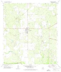
1972 Map of Big Wells
USGS Topo · Published 1974About this map
Big Wells sits as a centralized rail town in Dimmit County, anchored by the Missouri Pacific railroad line which bisects the landscape. In the early 1970s, the surrounding terrain was characterized by a mix of ranching and petroleum activity, evidenced by the expansive Big Wells Field and numerous oil wells scattered across the brush country. To the north of the main townsite, local history is preserved at the Big Wells Cem and St Michaels Cem, while the southern reaches of the quadrangle are defined by the winding course of the Nueces River.
Find a feature on this map
14 named features on this map. Tap any name to fly to it.
Don’t see what you’re looking for? This feature index may not catch every label — zoom into the map to look around manually.
Map Details
Editions of this 1972 Big Wells Map
This is the sole edition of this map. No revisions or reprints were ever made.
Other maps of this area

1925 · San Roque Lake 1-a
USGS Topo · 1:48,000

1927 · Bart
USGS Topo · 1:62,500

1929 · Cotulla
USGS Topo · 1:125,000

1932 · Valley Wells
USGS Topo · 1:62,500

1939 · Big Wells
USGS Topo · 1:62,500

1940 · Catarina
USGS Topo · 1:62,500

1940 · Artesia Wells
USGS Topo · 1:62,500

1953 · Crystal City
USGS Topo · 1:250,000

1955 · Crystal City
USGS Topo · 1:250,000

1956 · Woodward
USGS Topo · 1:62,500