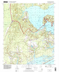
1997 Map of Sneads Ferry
USGS Topo · Published 2000About this map
Stones Bay and the tidal reaches of the New River dominate this coastal landscape, where the Camp Lejeune Military Reservation occupies significant shoreline acreage. The map records the interface between military land and civilian life, notably around the village of Sneads Ferry. The presence of several historic congregations, including Little Zion Ch, Yopps Ch, and Carrel Chapel, suggests a deep-rooted community structure along the primary roads leading to the water. Waterfront life is defined by a series of landings such as Stones Landing and Fulcher Landing, which served as critical access points for the local fishing and maritime economy before more modern developments like Chadwick Acres and various Mobile Home Parks began to reshape the residential pattern. The Intracoastal Waterway cuts through the southern marshes, linking Alligator Bay to the open Atlantic Ocean.
Find a feature on this map
45 named features on this map. Tap any name to fly to it.
Don’t see what you’re looking for? This feature index may not catch every label — zoom into the map to look around manually.
Map Details
Editions of this 1997 Sneads Ferry Map
This is the sole edition of this map. No revisions or reprints were ever made.
Other maps of this area

1942 · Spicer Bay
USGS Topo · 1:62,500

1942 · Topsail
USGS Topo · 1:62,500

1948 · Maple Hill
USGS Topo · 1:62,500

1948 · Topsail
USGS Topo · 1:62,500

1948 · New River
USGS Topo · 1:62,500

1952 · Camp Lejeune
USGS Topo · 1:24,000

1952 · Jacksonville South
USGS Topo · 1:24,000

1952 · Spicer Bay
USGS Topo · 1:24,000

1952 · New River Inlet
USGS Topo · 1:24,000

1952 · Sneads Ferry
USGS Topo · 1:24,000
Featured Places
- Sneads Ferry, NC
- Holly Ridge, NC
- North Topsail Beach, NC
- Marine Corps Base Camp Lejeune, NC
- Fulcher Landing, NC