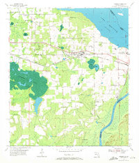
1954 Map of Sneads
USGS Topo · Published 1972About this map
Sneads stands as the primary hub in this mid-century portrait of Jackson County, situated where the Louisville and Nashville Railroad cuts across the landscape toward the Apalachicola River. The map captures a transitional water system, featuring the expansive Lake Seminole at the Georgia border and the sprawling, island-dotted waters of Ocheesee Pond to the southwest. This period of development is marked by institutions like the State Hospital Dairy and the Apalachee Correctional Institution, as well as local industry seen at the Pumping Station and Power Plant.
Find a feature on this map
45 named features on this map. Tap any name to fly to it.
Don’t see what you’re looking for? This feature index may not catch every label — zoom into the map to look around manually.
Map Details
Editions of this 1954 Sneads Map
2 editions found
Other maps of this area

1952 · Cypress
USGS Topo · 1:24,000

1952 · Dellwood
USGS Topo · 1:24,000

1952 · Altha East
USGS Topo · 1:24,000

1954 · Sneads
USGS Topo · 1:24,000

1954 · Tallahassee
USGS Topo · 1:250,000

1955 · Fairchild
USGS Topo · 1:24,000

1955 · Reynoldsville
USGS Topo · 1:24,000

1955 · Rock Bluff
USGS Topo · 1:24,000

1955 · Sycamore
USGS Topo · 1:24,000

1955 · Chattahoochee
USGS Topo · 1:24,000