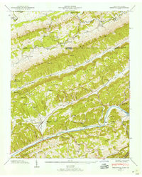
1946 Map of Sneedville
USGS Topo · Published 1958About this map
The Sneedville town site and the surrounding Clinch River valley are documented here just after the war, revealing a landscape defined by parallel ridges and deep hollows. The survey captures a high density of rural institutions, from the Vardy Community Sch and Dry Branch Sch to local landmarks like Thompson Mill and the Pressmens Home Power Plant. This era shows a community reliant on river crossings and mountain gaps, with Snodgrass Ford and Brooks Ford providing critical passage before more modern infrastructure.
Find a feature on this map
80 named features on this map. Tap any name to fly to it.
Don’t see what you’re looking for? This feature index may not catch every label — zoom into the map to look around manually.
Map Details
Editions of this 1946 Sneedville Map
3 editions found
Other maps of this area

1883 · Morristown
USGS Topo · 1:125,000

1887 · Jonesville
USGS Topo · 1:125,000

1891 · Jonesville
USGS Topo · 1:125,000

1893 · Morristown
USGS Topo · 1:125,000

1895 · Morristown
USGS Topo · 1:125,000

1932 · Hagan
USGS Topo · 1:62,500

1935 · Rogersville
USGS Topo · 1:48,000

1935 · Tate Springs
USGS Topo · 1:48,000

1935 · Kyles Ford
USGS Topo · 1:24,000

1935 · Lee Valley
USGS Topo · 1:24,000