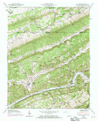
1946 Map of Sneedville
USGS Topo · Published 1970About this map
Sneedville serves as the focal point of this Appalachian terrain, where the ridge-and-valley topography of Northeast Tennessee meets the Virginia border. The landscape is defined by parallel heights including Wallen Ridge, Powell Mountain, and Newman Ridge, which channel the flow of the Powell River and Clinch River. Settlement patterns follow the narrow hollows and river bends, evidenced by numerous family cemeteries such as Vanderventer Cem and Goins Cem.
Find a feature on this map
74 named features on this map. Tap any name to fly to it.
Don’t see what you’re looking for? This feature index may not catch every label — zoom into the map to look around manually.
Map Details
Editions of this 1946 Sneedville Map
3 editions found
Other maps of this area

1883 · Morristown
USGS Topo · 1:125,000

1887 · Jonesville
USGS Topo · 1:125,000

1891 · Jonesville
USGS Topo · 1:125,000

1893 · Morristown
USGS Topo · 1:125,000

1895 · Morristown
USGS Topo · 1:125,000

1932 · Hagan
USGS Topo · 1:62,500

1935 · Rogersville
USGS Topo · 1:48,000

1935 · Tate Springs
USGS Topo · 1:48,000

1935 · Kyles Ford
USGS Topo · 1:24,000

1935 · Lee Valley
USGS Topo · 1:24,000