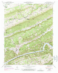
1946 Map of Sneedville
USGS Topo · Published 1989About this map
Sneedville sits at the heart of this ridge-and-valley landscape, where the Clinch River carves a deep path through Brush Ridge and War Ridge. The mapping reveals a rural Tennessee and Virginia borderland defined by its water gaps and specialized mountain infrastructure, such as the Pressmens Home Power Plant located along the river. A dense network of family-named cemeteries like Vandeventer Cem and Gollihon Cem, alongside landmarks like Thompson Mill, suggests a long-settled community rooted in the narrow valleys of Blackwater Creek and Greasy Creek. The survey documents numerous educational and spiritual centers including Vardy Community Sch, Ferguson Chapel School, and Thompson Settlement Church, which served the isolated hollows before modern consolidation changed the rural character of Hancock County.
Find a feature on this map
76 named features on this map. Tap any name to fly to it.
Don’t see what you’re looking for? This feature index may not catch every label — zoom into the map to look around manually.
Map Details
Editions of this 1946 Sneedville Map
3 editions found
Other maps of this area

1883 · Morristown
USGS Topo · 1:125,000

1887 · Jonesville
USGS Topo · 1:125,000

1891 · Jonesville
USGS Topo · 1:125,000

1893 · Morristown
USGS Topo · 1:125,000

1895 · Morristown
USGS Topo · 1:125,000

1932 · Hagan
USGS Topo · 1:62,500

1935 · Rogersville
USGS Topo · 1:48,000

1935 · Tate Springs
USGS Topo · 1:48,000

1935 · Kyles Ford
USGS Topo · 1:24,000

1935 · Lee Valley
USGS Topo · 1:24,000