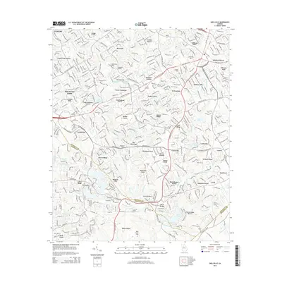
2014 Map of Snellville
USGS Topo · Published 2014About this map
Yellow River meanders through the heart of this landscape, carving a valley that defines the boundary between Gwinnett and DeKalb counties. The terrain is marked by distinctive granite outcrops and elevations, including Rock Chapel Mtn, Snellville Mtn, and the overlook at McDaniels Bluff. This 2014 snapshot captures the suburban transformation of the region, where older landmarks like Britt Shoals and the Annistown Bridge coexist with dense residential developments such as Rainbow Estates and Cumberland Forest. Genealogists will find a high density of burial sites across the quadrangle, from the large Eternal Hills Cem near Stonemont to smaller family and church plots like Sodom Cem, Livsey Cem, and Hannah Cem. The presence of the LT World Airport and the major corridor of Main Street W SW illustrates the modern infrastructure supporting this growing community.
Find a feature on this map
90 named features on this map. Tap any name to fly to it.
Don’t see what you’re looking for? This feature index may not catch every label — zoom into the map to look around manually.
Map Details
Editions of this 2014 Snellville Map
This is the sole edition of this map. No revisions or reprints were ever made.
Other maps of this area

1888 · Atlanta
USGS Topo · 1:125,000

1890 · Atlanta
USGS Topo · 1:125,000

1892 · Atlanta
USGS Topo · 1:125,000

1895 · Atlanta
USGS Topo · 1:125,000

1896 · Monroe
USGS Topo · 1:125,000

1953 · Atlanta
USGS Topo · 1:250,000

1953 · Athens
USGS Topo · 1:250,000

1956 · Stone Mountain
USGS Topo · 1:24,000

1956 · Snellville
USGS Topo · 1:24,000
1956 · Norcross
USGS Topo · 1:24,000