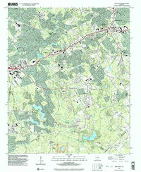
1999 Map of Snellville
USGS Topo · Published 2003About this map
The Yellow River winds through the heart of Gwinnett County on this 1999 survey, carving the distinctive Horseshoe Bend as it flows south toward the Rockdale County line. This era captures the significant suburban expansion around Snellville, where a dense network of schools like South Gwinnett High Sch and Norton Sch serves a growing population. The landscape is a mix of established residential pockets and natural landmarks, including the eastern reaches of Stone Mountain Memorial State Park and the prominent McDaniels Bluff overlooking Garner Creek. Local history is preserved in numerous family and community burial grounds, such as Eternal Hills Cem and the small Sodom Cem near the eastern border. The southeastern corner reveals industrial activity with a large Quarry near Rock Chapel, while the presence of Lake Lucerne and Norris Lake indicates the importance of recreational and residential water features in the area's development.
Find a feature on this map
102 named features on this map. Tap any name to fly to it.
Don’t see what you’re looking for? This feature index may not catch every label — zoom into the map to look around manually.
Map Details
Editions of this 1999 Snellville Map
This is the sole edition of this map. No revisions or reprints were ever made.
Other maps of this area

1888 · Atlanta
USGS Topo · 1:125,000

1890 · Atlanta
USGS Topo · 1:125,000

1892 · Atlanta
USGS Topo · 1:125,000

1895 · Atlanta
USGS Topo · 1:125,000

1896 · Monroe
USGS Topo · 1:125,000

1953 · Atlanta
USGS Topo · 1:250,000

1953 · Athens
USGS Topo · 1:250,000

1956 · Stone Mountain
USGS Topo · 1:24,000

1956 · Snellville
USGS Topo · 1:24,000
1956 · Norcross
USGS Topo · 1:24,000