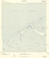
1943 Map of Snipe Keys
USGS Topo · Published 1943About this map
The Snipe Keys and surrounding archipelagos of Monroe County define this maritime survey, which captures the intricate waterways and mangrove islands during the Second World War. Established as Precinct 8, the area is a complex network of tidal flats and shallow basins, including Jewfish Basin and Turkey Basin. Navigational markers like Eaglenest Key BN 71 and Waltz Key BN 86 provide essential orientation through the tidal channels. The presence of Old Dan Mangrove near Fish Hawk Key highlights the specific coastal vegetation that historically shaped the Lower Florida Keys. Compiled from air photographs by the U.S. Coast and Geodetic Survey, the map documents the natural passages such as the Mud Key Channel and Barracuda Key Channel before significant modern development altered these remote shorelines.
Find a feature on this map
43 named features on this map. Tap any name to fly to it.
Don’t see what you’re looking for? This feature index may not catch every label — zoom into the map to look around manually.
Map Details
Editions of this 1943 Snipe Keys Map
2 editions found
Other maps of this area

1921 · Sugar Loaf Key
USGS Topo · 1:62,500

1921 · Key West
USGS Topo · 1:62,500

1943 · Bay Keys
USGS Topo · 1:24,000

1943 · Saddlebunch Keys
USGS Topo · 1:24,000

1943 · Boca Chica
USGS Topo · 1:24,000

1943 · Key West
USGS Topo · 1:24,000

1943 · Snipe Keys
USGS Topo · 1:24,000

1943 · Sugarloaf Key
USGS Topo · 1:24,000

1962 · Key West
USGS Topo · 1:24,000

1968 · Saddlebunch Keys
USGS Topo · 1:24,000