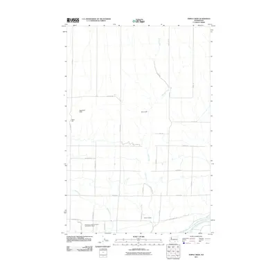
2011 Map of Snipes Creek
USGS Topo · Published 2011About this map
Washington State University Experimental Station stands as a prominent research landmark in this agricultural and desert landscape of Benton County. The terrain is defined by the steady descent of Snipes Creek and Spring Creek toward the Yakima River at the southern boundary. These seasonal watercourses carve through local landforms such as Kelly Gulch and Crow Canyon, while the higher elevations of Sagebrush Ridge and Royer Hill overlook a geometric grid of rural roads. The infrastructure of the area, including N Rothrock Rd and W Snipes Rd, reflects the systematic land use dedicated to large-scale agriculture and viticulture that characterizes this part of the Yakima Valley.
Find a feature on this map
31 named features on this map. Tap any name to fly to it.
Don’t see what you’re looking for? This feature index may not catch every label — zoom into the map to look around manually.
Map Details
Editions of this 2011 Snipes Creek Map
This is the sole edition of this map. No revisions or reprints were ever made.
Other maps of this area

1915 · Prosser
USGS Topo · 1:125,000

1917 · Prosser
USGS Topo · 1:125,000

1950 · Grandview
USGS Topo · 1:62,500

1951 · Grandview
USGS Topo · 1:62,500

1951 · Corral Canyon
USGS Topo · 1:62,500

1953 · Walla Walla
USGS Topo · 1:250,000

1958 · Walla Walla
USGS Topo · 1:250,000

1965 · Whitstran
USGS Topo · 1:62,500
1965 · Prosser
USGS Topo · 1:62,500
1965 · Prosser
USGS Topo · 1:24,000