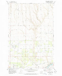
1977 Map of Snipes Creek
USGS Topo · Published 1978About this map
Agricultural research and irrigation infrastructure dominate this landscape in Benton County, centered on the Washington State University Experimental Station. The terrain transitions from the elevated Sagebrush Ridge and Kelly Gulch in the north toward the fertile valley of the Yakima River in the south. A complex network of water management features, including a prominent Aqueduct, Canal segments, and numerous siphons, illustrates the engineering required to sustain cultivation in this arid region.
Find a feature on this map
44 named features on this map. Tap any name to fly to it.
Don’t see what you’re looking for? This feature index may not catch every label — zoom into the map to look around manually.
Map Details
Editions of this 1977 Snipes Creek Map
This is the sole edition of this map. No revisions or reprints were ever made.
Other maps of this area

1915 · Prosser
USGS Topo · 1:125,000

1917 · Prosser
USGS Topo · 1:125,000

1950 · Grandview
USGS Topo · 1:62,500

1951 · Grandview
USGS Topo · 1:62,500

1951 · Corral Canyon
USGS Topo · 1:62,500

1953 · Walla Walla
USGS Topo · 1:250,000

1958 · Walla Walla
USGS Topo · 1:250,000

1965 · Whitstran
USGS Topo · 1:62,500
1965 · Prosser
USGS Topo · 1:62,500
1965 · Prosser
USGS Topo · 1:24,000