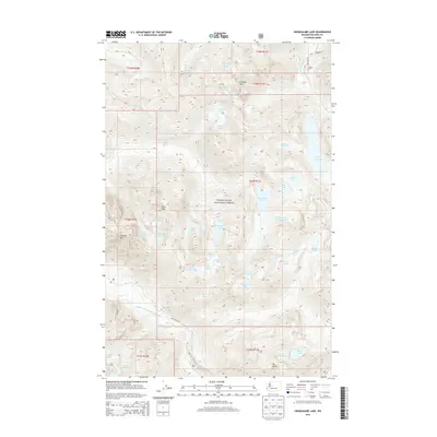
2014 Map of Snoqualmie Lake
USGS Topo · Published 2014About this map
Snoqualmie National Forest dominates this high-altitude terrain, where the headwaters of the Miller River and Snoqualmie River systems carve through the Central Cascades. This landscape is defined by its remarkable density of alpine basins, including the expansive Snoqualmie Lake and Lake Dorothy. The topography is anchored by prominent summits such as Cascade Mtn, Garfield Mtn, and Mt Price, which provide the backdrop for numerous smaller water bodies like Gouging Lake, Dream Lake, and the uniquely named Snoqualmie Lake Potholes. Local hydrologic features like Florence Falls and Otter Falls mark the steep descents of the E Fork and W Fork Miller Rivers. While mostly inaccessible by traditional roads, the presence of NFD 6412 RD and NFD 5620 RD indicates the limited corridor for forest management and backcountry access in this protected wilderness area.
Find a feature on this map
55 named features on this map. Tap any name to fly to it.
Don’t see what you’re looking for? This feature index may not catch every label — zoom into the map to look around manually.
Map Details
Editions of this 2014 Snoqualmie Lake Map
This is the sole edition of this map. No revisions or reprints were ever made.
Other maps of this area

1901 · Snoqualmie Pass
USGS Topo · 1:125,000

1902 · Skykomish
USGS Topo · 1:125,000

1903 · Snoqualmie
USGS Topo · 1:125,000

1905 · Skykomish
USGS Topo · 1:125,000

1913 · Cedar Lake
USGS Topo · 1:125,000

1921 · Sultan
USGS Topo · 1:125,000

1923 · Sultan
USGS Topo · 1:125,000

1957 · Wenatchee
USGS Topo · 1:250,000

1960 · Mount Si
USGS Topo · 1:62,500

1960 · Bandera
USGS Topo · 1:62,500