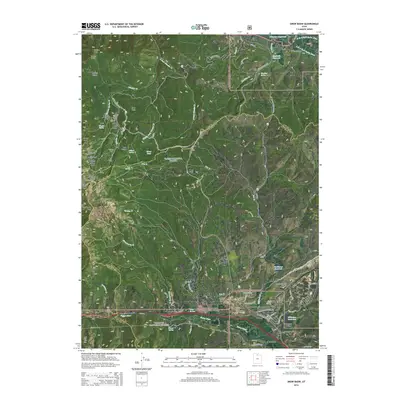
2014 Map of Snow Basin
USGS Topo · Published 2014About this map
Mountain Green and Peterson sit within the drainage of the Weber River as it cuts through the mountains south of Snow Basin. This corridor, where the Morgan Valley HWY 30 and the river pass through the Gateway gap, represents a critical transition between the high peaks of the Wasatch Range and the agricultural valley floor. The map documents a landscape defined by winter sports infrastructure and rugged natural landmarks, from the bowl formations like Easter Bowl and Strawberry Bowl to named peaks like De Moisy Peak and Sardine Peak. Small-scale water management is evident in the numerous mountain springs and catchments, including Hawkins Reservoir and Northwest Reservoir. The presence of the Mountain Green Cem and the Morgan County Airport near the intersection of Trappers Loop Rd highlights the mix of early settlement history and modern regional utility in this mountain pass.
Find a feature on this map
80 named features on this map. Tap any name to fly to it.
Don’t see what you’re looking for? This feature index may not catch every label — zoom into the map to look around manually.
Map Details
Editions of this 2014 Snow Basin Map
This is the sole edition of this map. No revisions or reprints were ever made.
Other maps of this area

1954 · Ogden
USGS Topo · 1:250,000

1955 · Ogden
USGS Topo · 1:24,000

1955 · Peterson
USGS Topo · 1:24,000

1955 · Huntsville
USGS Topo · 1:24,000

1955 · North Ogden
USGS Topo · 1:24,000

1955 · Kaysville
USGS Topo · 1:24,000

1955 · Snow Basin
USGS Topo · 1:24,000

1958 · Ogden
USGS Topo · 1:250,000

1960 · Ogden
USGS Topo · 1:250,000
1961 · Morgan
USGS Topo · 1:24,000