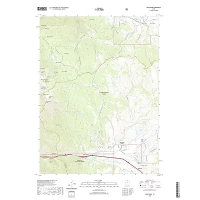
2020 Map of Snow Basin
USGS Topo · Published 2020About this map
Sardine Peak and De Moisy Peak tower over the western reaches of the Wasatch Range, framing the high-altitude terrain of Snow Basin. This area is characterized by steep glacial bowls including Upper Ogden Bowl and Strawberry Bowl, reflecting a landscape heavily shaped for winter recreation and mountain access. In the valley floor to the southeast, the Morgan Valley supports the growing communities of Mountain Green and Peterson. The Weber River cuts through the southern portion of the map, passing the engineering work at Gateway Tunnel. Transportation infrastructure is a prominent feature, with the Morgan County Airport situated near the confluence of Cottonwood Cr and the river. Genealogists may find interest in the Mountain Green Cem, while researchers can trace the path of the Old Highway Rd as it follows the historical corridor between the mountain peaks.
Find a feature on this map
81 named features on this map. Tap any name to fly to it.
Don’t see what you’re looking for? This feature index may not catch every label — zoom into the map to look around manually.
Map Details
Editions of this 2020 Snow Basin Map
This is the sole edition of this map. No revisions or reprints were ever made.
Other maps of this area

1954 · Ogden
USGS Topo · 1:250,000

1955 · Ogden
USGS Topo · 1:24,000

1955 · Peterson
USGS Topo · 1:24,000

1955 · Huntsville
USGS Topo · 1:24,000

1955 · North Ogden
USGS Topo · 1:24,000

1955 · Kaysville
USGS Topo · 1:24,000

1955 · Snow Basin
USGS Topo · 1:24,000

1958 · Ogden
USGS Topo · 1:250,000

1960 · Ogden
USGS Topo · 1:250,000
1961 · Morgan
USGS Topo · 1:24,000