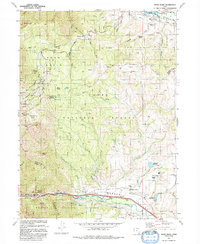
1992 Map of Snow Basin
USGS Topo · Published 1992About this map
Snow Basin and the surrounding high-altitude bowls of the Wasatch National Forest define this landscape at the start of the 1990s. The map illustrates the complex recreational and hydrological infrastructure of the region, from the ski runs of Middle Bowl and Strawberry Bowl to the intricate network of water management features like the Northwest Ditch and the South Fork Ogden River. In the lower elevations, the settlement of Mountain Green serves as a focal point near the Weber River, where the Mtn Green Cemetery and a County Airport mark the community's footprint.
Find a feature on this map
66 named features on this map. Tap any name to fly to it.
Don’t see what you’re looking for? This feature index may not catch every label — zoom into the map to look around manually.
Map Details
Editions of this 1992 Snow Basin Map
This is the sole edition of this map. No revisions or reprints were ever made.
Other maps of this area

1954 · Ogden
USGS Topo · 1:250,000

1955 · Ogden
USGS Topo · 1:24,000

1955 · Peterson
USGS Topo · 1:24,000

1955 · Huntsville
USGS Topo · 1:24,000

1955 · North Ogden
USGS Topo · 1:24,000

1955 · Kaysville
USGS Topo · 1:24,000

1955 · Snow Basin
USGS Topo · 1:24,000

1958 · Ogden
USGS Topo · 1:250,000

1960 · Ogden
USGS Topo · 1:250,000
1961 · Morgan
USGS Topo · 1:24,000