
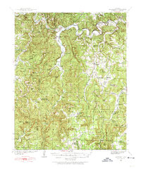
1939 Map of Snowball
USGS Topo · Published 1967About this map
The Buffalo River snakes through the northern reach of this landscape, defining a terrain of deep bends and high points like Point Peter and Rollins Mountain. During the late 1930s, this portion of the Ozark National Forest supported a network of small, isolated communities and family farmsteads connected by winding mountain roads. Settlements like Snowball and Witts Springs anchor the map, while numerous rural schools including Juanita Sch, Blanco Sch, and the uniquely named Welcome Home Sch suggest a decentralized but active social life in these hollows.
Find a feature on this map
120 named features on this map. Tap any name to fly to it.
Don’t see what you’re looking for? This feature index may not catch every label — zoom into the map to look around manually.
Map Details
Editions of this 1939 Snowball Map
2 editions found
Other maps of this area

1879 · Washington
USGS Topo · 1:62,500

1887 · Smyrna
USGS Topo · 1:62,500

1889 · Treat
USGS Topo · 1:62,500

1889 · Marshall #3
USGS Topo · 1:62,500

1892 · Marshall
USGS Topo · 1:125,000

1893 · Yellville
USGS Topo · 1:125,000

1894 · Marshall
USGS Topo · 1:125,000

1901 · Marshall
USGS Topo · 1:125,000

1903 · Yellville
USGS Topo · 1:125,000

1904 · Harrison
USGS Topo · 1:125,000