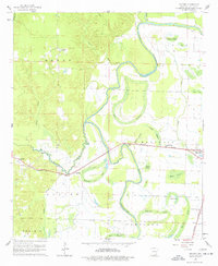
1960 Map of Snyder
USGS Topo · Published 1977About this map
Bayou Bartholomew winds through this Southeast Arkansas landscape, defining the transition from the upland woods of the Banner and Prairie districts to the fertile bottomlands of the Mississippi Delta. The Missouri Pacific railroad serves as the primary East-West corridor, connecting small settlements like Snyder and Montrose across the heavy delta soil. This era captures the area's agricultural reliance on the natural hydrology of the bayou system, where curved oxbows and brakes such as Lake Grampus, Simpson Brake, and Horseshoe Lake segment the terrain. Local social centers are anchored by country congregations, including Evening Star Ch near the tracks and New Providence Ch further south. The map reveals a land shaped by water, where drainage features like Bearhouse Creek and Overflow Creek dictate the placement of local roads and farmsteads.
Find a feature on this map
35 named features on this map. Tap any name to fly to it.
Don’t see what you’re looking for? This feature index may not catch every label — zoom into the map to look around manually.
Map Details
Editions of this 1960 Snyder Map
2 editions found
Other maps of this area

1935 · Mist
USGS Topo · 1:62,500

1935 · Wilmot
USGS Topo · 1:62,500

1936 · Eudora
USGS Topo · 1:62,500

1936 · Lake Village
USGS Topo · 1:62,500

1953 · Greenwood
USGS Topo · 1:250,000

1955 · Lake Village
USGS Topo · 1:62,500

1956 · Greenwood
USGS Topo · 1:250,000

1957 · Eudora
USGS Topo · 1:62,500

1960 · Snyder
USGS Topo · 1:24,000

1960 · Mist
USGS Topo · 1:62,500