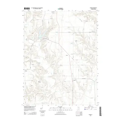
2015 Map of Snyder
USGS Topo · Published 2015About this map
Lincoln Trail State Park dominates the western landscape of this Clark County map, centered around Lincoln Trail State Park Lake and the drainage of Mill Cr. The surrounding terrain is defined by a dense network of watercourses, including Sugar Cr and Snyder Cr, which carve through the farmland to the east and south. A rural settlement pattern is evident through small communities like Ernst, Choctaw, and Snyder, which are linked by an extensive system of range and section line roads. Genealogists will find significant value in the distribution of family and community burial sites, such as Big Creek Cem, Bubeck Cem, and Blizzard Cem. To the north, the southern edge of Marshall provides a transition from town to the more dispersed homesteads that characterize the area around Lost Hill and Allright.
Find a feature on this map
73 named features on this map. Tap any name to fly to it.
Don’t see what you’re looking for? This feature index may not catch every label — zoom into the map to look around manually.
Map Details
Editions of this 2015 Snyder Map
This is the sole edition of this map. No revisions or reprints were ever made.
Other maps of this area

1932 · Marshall
USGS Topo · 1:62,500

1936 · Casey
USGS Topo · 1:48,000

1937 · Marshall
USGS Topo · 1:62,500

1942 · Fairbanks
USGS Topo · 1:24,000

1942 · Hutton
USGS Topo · 1:24,000

1942 · Dennison
USGS Topo · 1:24,000

1942 · Casey
USGS Topo · 1:62,500

1943 · Casey
USGS Topo · 1:62,500

1952 · Fairbanks
USGS Topo · 1:24,000
1952 · Hutton
USGS Topo · 1:24,000