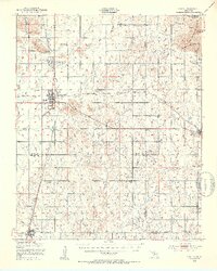
1950 Map of Snyder
USGS Topo · Published 1953About this map
St Louis-San Francisco rail lines intersect at the heart of this post-war Oklahoma landscape, anchoring the bustling town of Snyder. The map illustrates a rural society organized around crossroads communities and education, with several country schoolhouses such as Richland Sch, Horse Creek Sch, and Belmont Sch serving the surrounding farms. To the east, the topography shifts dramatically as the plains meet the rocky elevations of the Wichita Mountains Wildlife Refuge, where landmarks like Charons Garden Mountain and Sunset Peak rise above the terrain. These granite outcrops contrast with the creek-fed lowlands of Otter Creek and Sandy Creek, while the presence of scattered ruins and rural cemeteries like Mountain Park Cem provides a detailed record of the early 20th-century settlement patterns in Kiowa and Comanche counties.
Find a feature on this map
44 named features on this map. Tap any name to fly to it.
Don’t see what you’re looking for? This feature index may not catch every label — zoom into the map to look around manually.
Map Details
Editions of this 1950 Snyder Map
2 editions found
Other maps of this area

1937 · Cache
USGS Topo · 1:48,000

1937 · Quanah Mountain
USGS Topo · 1:24,000

1942 · Cache
USGS Topo · 1:62,500

1949 · Cooperton
USGS Topo · 1:62,500

1949 · Quanah Mountain
USGS Topo · 1:24,000

1950 · Snyder
USGS Topo · 1:62,500

1950 · Saddle Mountain
USGS Topo · 1:62,500

1955 · Lawton
USGS Topo · 1:250,000

1956 · Post Oak Creek
USGS Topo · 1:24,000

1956 · Glen Mountains
USGS Topo · 1:24,000