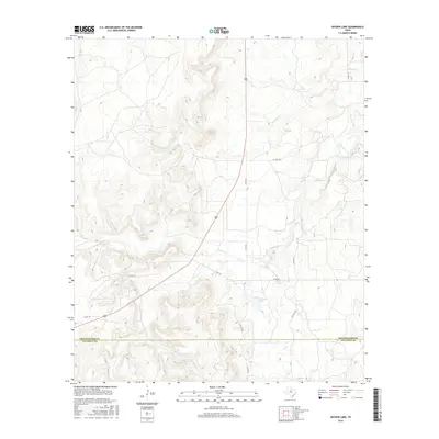
2016 Map of Snyder Lake
USGS Topo · Published 2016About this map
Hubbard Cr and its various tributaries define the drainage patterns of this West Texas landscape, where the boundary between Shackelford Co and Callahan Co cuts through a region shaped by ranching and resource management. Two primary bodies of water, Snyder Lake and Diller Lake, serve as focal points for the local hydrology in an area otherwise characterized by intermittent stream beds like Reynolds Cr and Jenkins Cr. The road network is a mixture of state-maintained routes such as FM 576 and a web of county and private roads, including Co Rd 162 and Pvt Rd 2160, which provide access to the expansive properties of the cross-county borderlands. This 2016 survey illustrates the persistent rural character of the region, emphasizing the importance of water catchment and secondary transportation routes in a territory defined by its topographic relief and creek systems.
Find a feature on this map
17 named features on this map. Tap any name to fly to it.
Don’t see what you’re looking for? This feature index may not catch every label — zoom into the map to look around manually.
Map Details
Editions of this 2016 Snyder Lake Map
This is the sole edition of this map. No revisions or reprints were ever made.
Other maps of this area

1892 · Albany
USGS Topo · 1:125,000

1893 · Albany
USGS Topo · 1:125,000

1931 · Baird
USGS Topo · 1:125,000

1932 · Baird
USGS Topo · 1:125,000

1954 · Abilene
USGS Topo · 1:250,000

1958 · Abilene
USGS Topo · 1:250,000

1965 · Acampo
USGS Topo · 1:24,000

1965 · Albany
USGS Topo · 1:24,000

1965 · McCatherine Mountain
USGS Topo · 1:24,000
1965 · Snyder Lake
USGS Topo · 1:24,000